


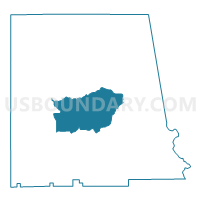
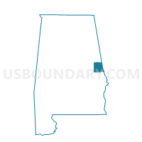
LaFayette, Chambers County, Alabama
About
Outline

Summary
| Unique Area Identifier | 521324 |
| Name | LaFayette |
| County | Chambers County |
| State | Alabama |
| Area (square miles) | 47.85 |
| Land Area (square miles) | 47.61 |
| Water Area (square miles) | 0.24 |
| % of Land Area | 99.50 |
| % of Water Area | 0.50 |
| Latitude of the Internal Point | 32.89283720 |
| Longtitude of the Internal Point | -85.39412880 |
Maps

Graphs
Select a template below for downloading or customizing gragh for LaFayette, Chambers County, Alabama


Neighbors
Neighoring Voting District (by Name) Neighboring Voting District on the Map
- Buffalo-Lebanon /Five Points /Penton Voting District, Chambers County, AL
- Cusseta, Chambers County, AL
- Fredonia Voting District, Chambers County, AL
- Lakeview/Lanett/Huguley Rescue Voting District, Chambers County, AL
- Ridgegrove, Chambers County, AL
- Sturkie Voting District, Chambers County, AL